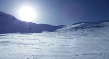
If you enjoy wide open bowl skiing in the alpine, there are several nice options on the north side of Wing Ridge that you can access from Salt Creek Summit Snopark. This is one of the most popular backcountry ski destinations in the Wallowas because of the proximity to Joseph and a drive-able winter road up to one of the highest winter-maintained roads in the state, at 6,120' at the snopark. The immediate access to the ski terrain is a bonus too. And did I mentioned the terrain is awesome! You'll find big lines with awesome views over Hell's Canyon and the Seven Devils mountains of Idaho.
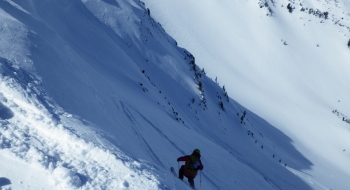
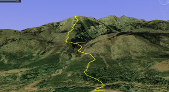
Phat Ridge is one of the safer, more straightforward ways to access the eastern-most point of Wing Ridge from Salt Creek Summit Snopark. You will mainly follow the Wing Ridge summer trail until you get to Phat Ridge and then follow the ridge up to the top. Skiing any of the north aspects can get you back to the same skin track up if you ski down the drainage. Another option is to take Middle Ridge up to The Pyramid (see EnterActive Map) where you can traverse to have your pick of First Basin, Second Basin, and any other line that looks appealing. This route takes you past the Wing Ridge Hut, 1100' into the climb (at 7,160' elevation.) on the plateau seen on the topo map. Another popular ski route is South Bowl (also shown on EnterActive Map).
Salt Creek Summit is also a checkpoint for the Eagle Cap Extreme Sled Dog Race.
All of this terrain deserves respect and caution for avalanches, as the trees show the a history of some big avalanches, it is important to note some recent close calls in South Bowl (see here and here)
Access
By car, you can only access the snopark from the north via Joseph. The loop road from Halfway is not maintained in the winter, although it is accessible by groomed snowmobile trail from Halfway.