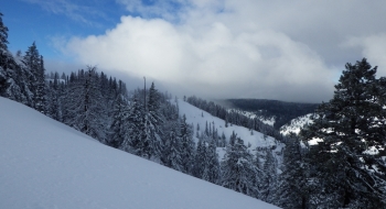
This section of the blue mountains near Spout Springs Ski Area can generate a lot of snow. The Sno-Parks along the highway start near the highest elevations in Blue Mountains and plateaued ridges allow for cruising around on snowmobiles with a lot of options to ski down some steep drainages. This 20 minute snowmobile to Shamrock Spring allows for some skiing down to the North Fork of the Umatilla River drainage. Timing is important for getting the most of skiing here, as the lower elevations can melt off quickly.
The snowmobile route follows Summit Road to Nine Mile Trailhead, and then takes the ridge north out to the skiing. The location can be reached by AT skiing through the non-motorized Horshoe Pairie Nordic Area from Andies Prairie but that is a rather long flat hike.
This is tricky skiing and the trees can be thick and terrain traps everywhere so make sure safety and stability is a priority.
