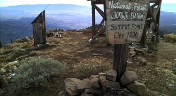
What a beautiful climb this is! Starting in the small community of Carson, near Halfway, the Grade starts and 3300 feet and climbs up to 4600 feet where it meets up with FS77 road. A short trip over to McBride campground and the climbing kicks up again all the way up to the Summit Point Lookout at 7000 ft.
The gravel road is in good condition all the way to the trailhead. Then, the last mile is a non-motorized ATV trail up to the lookout, which makes for rough and steep riding on your cross bike. As you can expect, the views are worth the trip up to the lookout, which is manned in the fire season. You will see Cornucopia Peak to the north, the Elkhorns to the west, Lookout Mountain to the south, and Hells Canyon to the east.
Notes
- 0.0mi Start by heading west on Carson Ln in the town of Carson.
- 3.2 This is the official end of the Carson Grade, when you connect with NF-77 road. Take a right on this road.
- 4.0 Arrive at a road intersection where you will turn right. McBride Campground is on the left.
- 8.7 Summit Point Trailhead parking. You will continue on the trail, which is an old road and ATV track and the going gets much rougher and steeper.
- 9.1 Trail intersection. The Summit Point Trail continues straight, but the road to the lookout switches back and heads up to the ridge.
- 9.6 Arrive at the lookout.