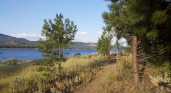
The most beginner of true singletrack trails in the entire region is offered up by Phillips Lake in the form of the Shoreline Trail. This trail hugs the shoreline around the entire lake, offering fantastic views and full-throttle riding. Other than the rocky section at the west end (which can be bypassed) any inexperienced rider will enjoy a positive first singletrack riding experience on this trail. More experienced riders may enjoy some side trails featured on our EnterActive map. The surface is mostly smooth-packed dirt with some gravel on some sections of the trail. There are very few obstacles or roots along the trail. The trail is also very well marked with information signs and blue diamonds on the south shore. There are many entry points from the roads and at campgrounds around the lake.
Trail Notes
- The route here is shown counterclockwise from the south end of Mason Dam. There is ample free parking here.
- After crossing the dam on your bike, there is no direct access point to the trail because it dead-ends on the rocks above the dam. Ride out to the highway and then up to the first boat launch. Alternately, you can hike a bike over to the trail once you have passed the fence at the top of the hill. The trail resumes on the right near the boat launch.
- At Union Springs Campground you can ride up to the out-and-back Indian Rock Lookout trail.
- A few miles after the campground the trail comes onto the highway. Travel down the highway over the bridge of Deer Creek and then look for the trail immediately on the left.
- Travel through Mowich Loop picnic area, which is another good trail entry point.
- Continue on the trail past the picnic area. If you end up coming up on the highway, you've missed sharp U-turn in the trail that takes you down to the shoreline, this exit is needed if the lake level is high enough or the ground is swampy. This will also be a good bypass point for beginners to take the highway to Hudspeth Ln and then reconnect with the route there. Otherwise, you can continue down to where a sign marks the trail and then head west along the banks of the lake.
- There will likely be some tire tracks, signs, or rockpiles to help guide you, but otherwise just stay on the high ground areas. This section of the trail is the roughest because it is rocky and overgrown.
- The trail comes out on Hudspeth Ln, go left and then take the next left onto the gravel roads to the south shore campgrounds. Shortly, the singletrack trail will resume on the left. The trail is very good from here back to the dam.
- There is a trail junction for the Rim Rock Trail and the Deer Lick Trail on the way back to the dam.
- Near the dam the trail does go cross a road at a popular primitive camp spot on the shore. You will find a bridge on the left to get back on the trail.