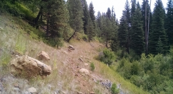
We don't have many mountain bike trails along a river in this region. Currently, this isn't one either, but it could be. This old road was scrubbed out and a re-vegetation process is under way along the South Fork Catherine Creek. Surprisingly, a singletrack trail has replaced it, but it is going to take some work to be rideable. The trail is mostly just above the old road and is a continuous track from start to finish, which would be a great downhill ride from the Sand Pass Trailhead area. I'm not sure how it got there since it isn't a official trail, but presumably it was formed by some free-range cattle or a cattle drives. In any case, it probably only needs one or two people to walk the entire route and chuck the loose stones off of it and then it just needs a little use to beat back the encroaching grass. Otherwise, it is about ready to go once you can see the trail surface and have some reasonable assurance you won't T-bone a rock in the trail.
It meanders along the nicely flowing creek except for a few places where it departs and goes high on the steep embankment before dropping back down to the creek. There are signs of some trailwork taking place on parts of the trail. The bottom end is accessible across a bridge where the South Fork and North Fork come together, just below the Buck Creek Bridge. There is a gate that is open and a short ways up there are some berms and a place to park. You can also park at the pullout before crossing the bridge. At the upper end, the Sand Pass Trailhead isn't too far away, but there are plenty of other places to park. However, you may want to drop down on your bike from either Taylor Green or Buck Creek Campground to save some rough road travel. You can also get some riding up the Sand Pass Trail which also follows the creek quite a ways up. This route used to be the old snowmobile route before the Catherine Summit Snopark was developed.