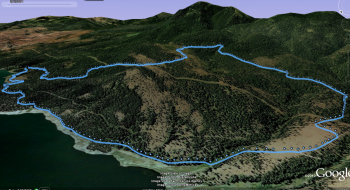
This cross-country ski trail mainly consists of fire roads and some ambiguous singletrack on old (as still used) road. The route shown here is from west to east, which offers a moderately long climb on mostly roads and a rocky descent on a mix of singletrack and road. Either direction should be okay, but it isn't the best distinction of a mountain bike trail by the Forest Service. The trail isn't very technically challenging, but is very rough and rocky in sections so moderate to expert riders in good physical condition should enjoy it. The route is very well marked with blue diamonds, making it very easy to follow. There are a few stiles over fences that you have to cross. While traveling under the power lines, be sure not to miss the trail sign on the left, to cross a fence and cruise back to the trailhead on singletrack.
Get to the trailhead by crossing Mason Dam at Phillips Lake and drive south about a quarter mile to a trailhead on the left. Or, access it from a Shoreline Trail entry point.


 from the Shoreline Trail (Left), on the west end.")